

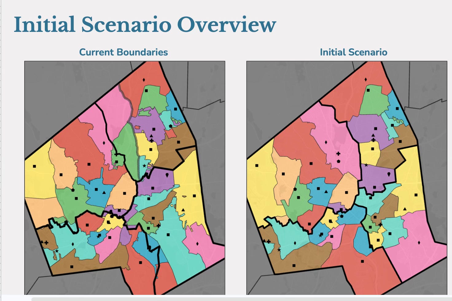
Worcester Public Schools released its first districtwide redistricting scenario ahead of Tuesday’s School Committee Operations and Governance meeting. You can review the meeting agenda, presentation, and administration’s report . Here is the interactive scenario map. For more background on why WPS is undertaking this process and how it began, read my initial redistricting overview from March.
Let’s dive in:
What problem is WPS trying to solve?
Districtwide, WPS has enough elementary school space. Elementary buildings are currently about 84% full overall, which is considered an ideal utilization rate. The problem is where those seats are located. Individual elementary schools range from 57% utilized to 113% utilized. Some schools are significantly overcrowded, while others have substantial unused space. Current elementary boundaries also include disconnected “satellite” zones, divide neighborhoods and send students from the same elementary school to different middle and high schools.
The initial scenario attempts to:
Bring elementary schools into a narrower utilization range of approximately 77% to 92%.
Eliminate split feeder patterns so students from the same elementary zone continue together to middle and high school.
Remove disconnected satellite zones.
Place at least one Pre-K classroom in every elementary school over time, as funding becomes available.
Create districtwide access to magnet and technical programs rather than limiting access by quadrant.
Address expected enrollment growth from new housing developments.
Better align school enrollment with actual building capacity.
This is a complicated puzzle. Moving one boundary to relieve overcrowding can increase transportation time. Keeping students close to home can result in unequal building utilization. Expanding access to specialized programs may require moving those programs or changing how students are admitted. Many of these same tensions—including transportation, equity, school capacity and disruption to students—were raised during the district’s first community forum in March.
There is no scenario that maximizes every priority at once. We can do anything, but we cannot do everything. Still, many of these issues are successfully addressed in the initial redistricting scenario.
What would change?
Almost every single school geographic boundary has some change— you can look at them more closely here. The biggest change is that every elementary school would feed into one middle school, and every middle school would feed into one high school. No more kids getting split at transition years!
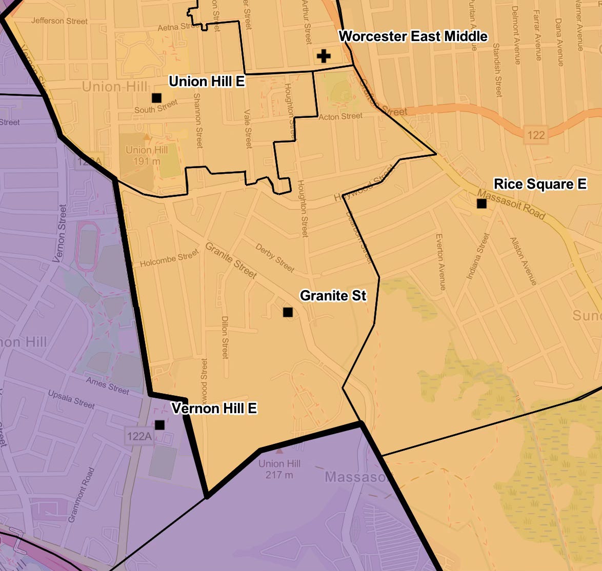
A quick breakdown of notable changes in the draft scenario include:
Belmont Street would move from the North Quadrant to Burncoat.
Columbus Park would move from the South Quadrant to Doherty
Jacob Hiatt would become a neighborhood school in the South Quadrant.
The Gerald Creamer building on Granite Street would become a neighborhood school again, serving Pre-K–6 and helping relieve Rice Square and Grafton Street. The GCC program would move to the Fanning Building.
Rice Square and Grafton Street sixth graders would attend Worcester East Middle. Rice Square sixth graders began attending Worcester East last school year.
The current Worcester Arts Magnet building would become a neighborhood school serving the growing Burncoat area.
The arts magnet program could move to the Francis McGrath building, while the McGrath neighborhood zone would largely become part of Nelson Place.
Plumley Village would be assigned entirely to City View instead of being divided between City View and Belmont Street.
Worcester Dual Language Magnet would remain a districtwide, lottery magnet school.
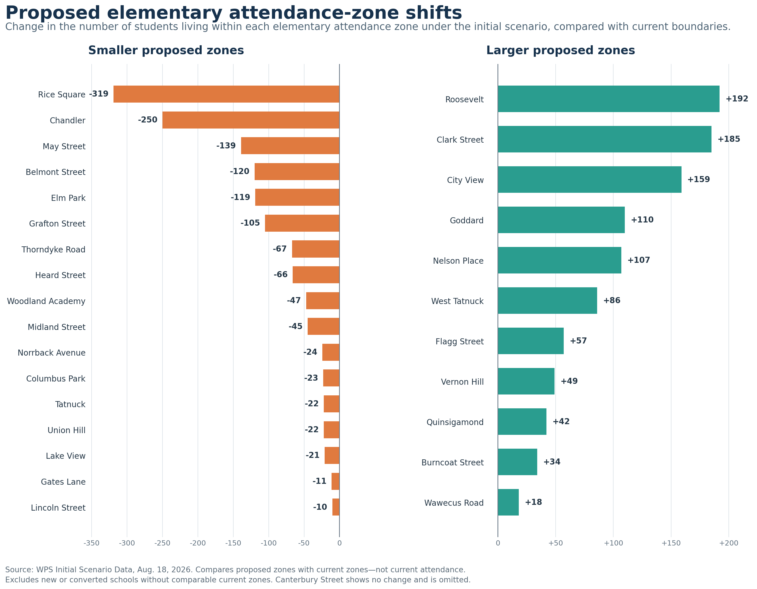
In terms of individual school zones, some of the largest reductions would be at Chandler Elementary and Rice Square. May Street, Elm Park, Grafton Street, Heard Street, Thorndyke Road and Midland Street would also have smaller zones. On the other side, City View, Nelson Place and Goddard would receive substantially larger zones, while West Tatnuck, Roosevelt, Clark Street, Flagg Street, Quinsigamond and Vernon Hill would also serve larger areas.
The chart I made below shows the net change in the number of students living within each elementary attendance zone (not the change in current school enrollment!) For example, 732 students currently live within the Rice Square zone, but only 421 attend Rice Square. Under the proposed scenario, the number of students living within the Rice Square zone would drop to 413. In other words, the chart shows how many students would be added to or removed from each school’s geographic zone, not necessarily how many students would enter or leave the school.
Secondary Schools.
At the secondary level, the challenge is different. Worcester’s middle and high school buildings are not proportionally sized. Doherty High has considerably more space than its feeder middle school (Forest Grove), while the South Quadrant has more middle school capacity (Sullivan) than high school capacity (South High). The presentation suggests that boundary changes alone cannot solve this problem.
One presented potential solution is a districtwide high school lottery or controlled-choice process to fill seats beyond those assigned through each quadrant’s regular feeder pattern. If that moves forward, families will need clear, public information about how seats are assigned and how equitable access will be ensured.
School Time Changes.
The proposal would also establish three school-day tiers: 7:15 a.m.–1:38 p.m. for high schools, Burncoat Middle and specialized programs; 8:15 a.m.–2:38 p.m. for other middle schools and elementary special education hubs; and 9:05 a.m.–3:28 p.m. for neighborhood elementary schools. Several schools would also be renamed to remove terms such as “community” or “magnet” when those labels no longer reflect their programming.
What should you keep in mind?
This is an initial scenario, not a final plan. It is intended to give the community something concrete to review and improve.
The plan also depends on WPS addressing voluntary transfers. About 14% of non-special education elementary students currently attend outside their assigned zones. If that continues, the new boundaries will not create the balance shown in the scenario.
Most schools would not see dramatic demographic changes under this scenario, but there are some notable shifts. Nelson Place and West Tatnuck would serve more low-income students, while Norrback, May Street and Thorndyke Road would serve fewer.
We also do not yet know when changes would begin, whether they would be phased in, or whether current students and their siblings could remain at their schools. Those details will obviously matter enormously to families, but we are not at that implementation stage yet.
What’s Next?
Right now, the district is asking for feedback, and this is where your local knowledge can be especially helpful: unsafe walking routes, natural neighborhood connections and places where a proposed line simply does not make sense. Families can see their current and proposed assignments and submit feedback through the district’s Community Input Mapping Tool or email alignment@worcesterschools.net. Of course, look at what the proposal means for your own family. But also look at the bigger picture: Does it use our buildings more fairly? Keep neighborhoods together? Create clearer pathways for students? Expand access to programs and opportunities?
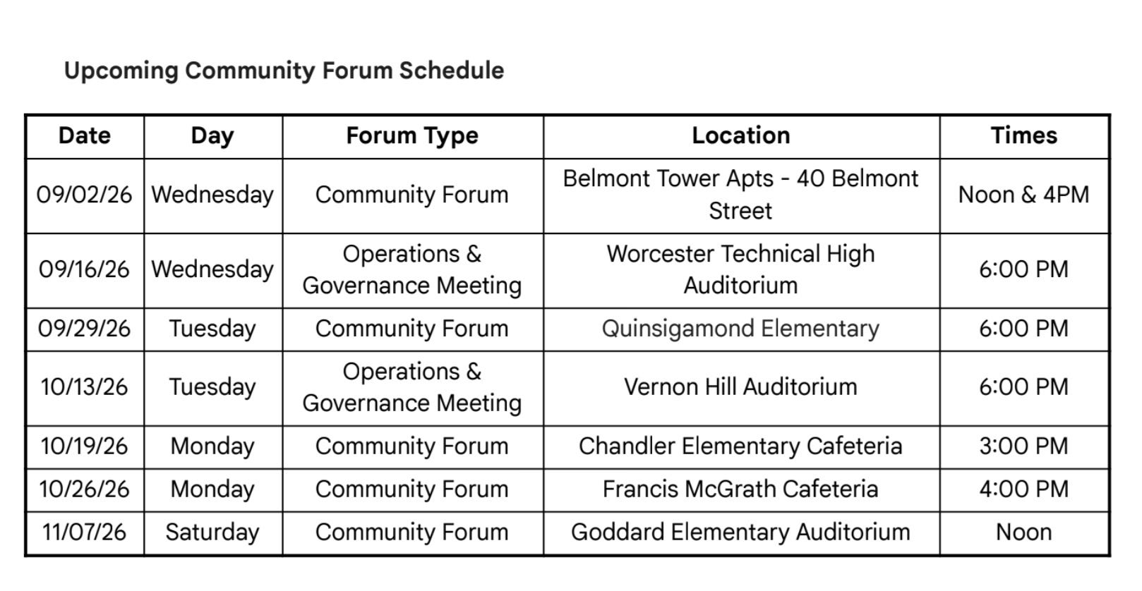
Final scenarios are expected to go to the School Committee in December, following public meetings and community forums throughout September, October and November (see below).
There will not be a perfect map. But this is a once in a generation opportunity to make it better, and to build a stronger WPS for all our kids.
This is the first article I have read that really explained it well in a way I could understand.
Thank you as always for your excellent explanations,